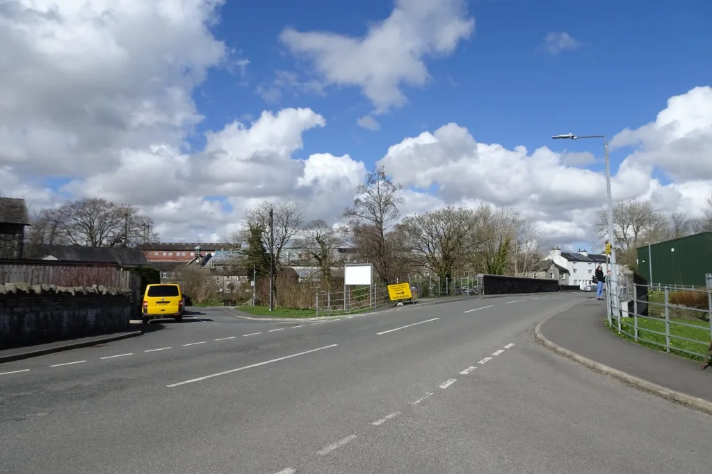

Officers want the Burneside 20mph order made despite 18 of 20 responses objecting. Grasmere, Crosscrake and the County Hall car park are decided the same night, 6pm at Kendal Town Hall.
Councillors decide on Thursday 15 October whether to make the 20mph order for Burneside, Grasmere, Crosscrake and four other places in the south Lakes. Officers recommend making it exactly as advertised, after a statutory consultation that drew 121 representations. (Report to South Lakeland Locality Board, 15 October 2026)
The South Lakeland Locality Board meets at 6pm in the District Council Chamber at Kendal Town Hall on Lowther Street. The 20mph order is item 9 on the agenda and the County Hall car park order is item 10. (Agenda)
We set out the roads in the draft order in August. In Burneside it covers 11 lengths of road, with a 30mph limit on part of Hollins Lane as a buffer. Our report on the consultation lists them all.
Burneside: 2 in support, 18 against
Burneside, about two miles north of Kendal, drew 20 responses from the public: 2 in support and 18 objections. Burneside Parish Council responded separately in support of the 20mph proposals and the 30mph change on Hollins Lane. (Appendix 4, summary of representations)
The 18 objections are not 18 different arguments. The council’s summary records that 15 of them repeat the same wording, objecting to the proposed 30mph buffer on the C5057 Hollins Lane. That objection says a 30mph stretch immediately before the 20mph zone could make drivers less likely to notice or obey the lower limit, and asks the council for evidence that the buffer improves safety.
The other three objections say:
- the council has not published collision, casualty or speed survey data for the Burneside roads, so the case for a village-wide limit has not been made. This respondent asks for targeted limits near the school and play areas with physical calming instead, and points out that the same order puts 30mph on other Burneside roads, which suggests not every road warrants 20mph
- signage-only limits are poorly self-enforcing on through routes such as Hollins Lane and New Road, and the police cannot realistically enforce them
- the proposals are “absolutely not needed except by the school”
The two supporters describe a rat-run from the A6 through the village and up Hollins Lane to the A591, the lack of a footway between the cricket club and the village centre, lorries serving the James Cropper mill, St Oswald’s school at peak times, National Cycle Route 6 through the village, and the single-lane effect of parked cars on Winter Lane in Bowston.
Officers answer that the limits are “a proactive measure” to cut the risk of a collision involving a vulnerable road user, “up to 70% less risk of a fatality”. They say the 20mph programme is funded separately from the highways capital budget, that enforcement “will be proportionate” through existing police resources, and that the community backed the scheme at the informal stage. The recommendation is to implement it as advertised.
The same 15 objections went to Crosscrake and Grasmere
The fifteen respondents whose Burneside objection repeated one text (the council numbers them SL60 to SL74) also objected to the Crosscrake and Grasmere schemes, each time with a shared wording.
- Crosscrake, about three miles south of Kendal: 16 responses, all objections. The shared objection says the C5074 has a 60mph limit, and that the council’s own criteria for 20mph schemes say the existing limit “can be no higher than 40mph”. Officers reply that the Crosscrake scheme was developed outside the 20mph programme, so the programme’s criteria do not apply to it, that those criteria are guidance rather than a legal test, and that the initial consultation had “unanimous support”.
- Grasmere: 23 responses, 7 in support and 16 against. The supporters are about Red Bank Road, which has no pavement and carries hundreds of walkers a day on the lake circuit. The 16 objections use the same 40mph-criteria wording as Crosscrake. The Lake District National Park Authority supports the Grasmere, Outgate and Lowick schemes but asks for a signage plan that respects the World Heritage Site landscape on Red Bank Road. The council’s own active travel team also supports it and says a separate scheme will propose cutting the A591 from the national limit to 50mph between Grasmere and the top of Dunmail Raise.
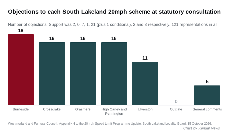
Elsewhere in the order, High Carley and Pennington drew 1 response in support and 16 against, Outgate drew 2, both in support, and Ulverston drew 33, with 21 in support, 1 conditional and 11 against. Eight general comments not tied to a place split 3 to 5 against. Officers recommend every scheme as advertised.
Two things in the papers are worth knowing before Thursday:
- The officers’ written answer on Grasmere refers to “the C5074”, which is the Crosscrake road. The Grasmere response appears to have been copied from the Crosscrake one.
- The statutory notice still lists Sedgwick among the places “introducing” a 20mph limit. As we reported in August, Sedgwick appears in the draft order only in a clause revoking a 2025 30mph provision. The summary of responses has no Sedgwick section.
The order’s title in the report reads “Variation (No. 5) Order 202><”, with the year left as a placeholder.
County Hall car park: no objections, one question
Item 10 on the same night is the order that removes Areas 1, 2 and 4 of the County Hall car park on Stricklandgate from the council’s parking order, so they can be included in the sale of the building. We reported the proposal in August.
The report says the statutory consultation ran from 27 August to 16 September and that no objections were received. The only query came from Councillor Matt Severn, who asked whether parking in the revoked areas would be free or banned. The report’s answer is that the amendment is “to allow sections of the car park to be included within the sale agreement”, which does not say either. (Report, item 10)
Other detail from the papers:
- the order process costs about £3,500 in staff time and advertising; removing the machines and signs comes from the estates capital budget
- the equality screening says the disabled bays in Area 1 “will no longer form part of the Council-managed parking area”, that four disabled bays remain in Area 5, which the council keeps, and that it “may consider” adding more
- the screening form’s opening lines describe a parking order for Springfield Road in Ulverston and restrictions on Stock Ghyll Lane in Ambleside, text left over from other orders (Appendix 4, updated)
The recommendation is to bring the order into operation as advertised. The main pay and display car park at the rear is not part of it.
Also on the agenda
- Kendal’s small active travel fixes add up to £6m. The Highways and Traffic Working Group heard on 9 September that a council study has identified more than 600 small-scale improvements for walking and cycling in Kendal, each worth up to £50,000, totalling over £6m. A separate cycle parking study, paid for by Kendal Town Council, has produced a programme of new and improved cycle parking across the town. Funding for a first package is expected in the autumn, with the scope to be agreed with the town council in October. (Highways and Traffic Working Group report)
- National Highways did not turn up. Its contractor Kier was due to brief the group on the M6 closures and their knock-on for local roads, and sent apologies “at short notice”. The board is asked to invite National Highways to the January meeting to explain the M6 Lune Gorge project.
- Community Infrastructure Levy. The council has collected £9.79m, has £7.1m available for new projects and has allocated £3.6m. Kendal schemes already recommended include a new cycle pump track at Sandylands (£140,000), the refurbishment of Stricklandgate House (£200,000), playground refurbishments at Hawthorn Gardens, Levens Close and Greenwood Drive (part of a £200,000 five-site scheme) and the Kendal to Hincaster section of the Lancaster Canal towpath (£728,871). A business case is being prepared for £167,587.50 of highway work at Sandes Court so that flood defences can be built between Sandes Avenue and County Hall. (CIL project updates)
What it means for you
- The decision is Thursday evening, and the public can attend. The deadline for written questions to the board was three clear working days before the meeting, which has already passed, so the way to be heard now is to be in the room.
- If the order is made, the signs follow this financial year. The report says delivery is funded from the Priority Investment Fund, second homes income and the Local Transport Grant, and is planned within 2026/27.
- Burneside’s buffer is the live argument. Fifteen of the eighteen objections are about the 30mph stretch on Hollins Lane, not the 20mph village limit. If the board makes the order as advertised, both go in together.
- County Hall’s bays go with the building. Blue badge holders who used the three-hour free stay at the front of County Hall will be left with the four bays the council keeps in Area 5. Our parking in Kendal page lists the alternatives.
We will report the outcome. For road closures in the meantime, see our Kendal roadworks and travel page.
Have your say