
Planners back up to 49,507 sq m of industry and warehousing on fields north of Meadowbank, Kendal. Councillors decide on 12 November.
Council planners are recommending approval for a large business park on green fields at the northern edge of Kendal. It would sit west of the A6 Shap Road, just north of Meadowbank Business Park.
The outline application, ref 2025/2124/OPA, goes to the council’s new single Planning Committee on Thursday 12 November at 10am at Kendal Town Hall. It is the only application on the agenda.
The applicant is Watch This Space Property Limited. Its documents call the scheme Flock Business Park.
What is proposed
The site covers 13.5 hectares. The application sets a ceiling of 49,507 square metres of floorspace, according to the officers’ report. That breaks down as:
- up to 45,007 sq m on the ground floor, plus up to 4,500 sq m of mezzanine for storage only
- up to 18,854 sq m for industrial use (classes B2 and E(g)(iii))
- up to 560 sq m for food and drink, with no more than 345 sq m of it for a “fast food drive-thru”
- everything else available for storage and distribution (class B8)
The food and drink units would be limited to two plots on the A6, either side of the entrance. Buildings would be up to 12 metres high, or 9.5 metres in the areas officers judge more sensitive.
The main access would be a new junction on the A6, rebuilt from the existing track to Gilthwaiterigg Farm. Two emergency accesses, onto the Meadowbank slip road and Gilthwaiterigg Lane, would double as walking and cycling links.
Everything else, including layout, appearance and the exact junction design, is left for a later “reserved matters” application.
Why it is going to committee
Only part of the site is in Kendal’s development boundary. 5.15 hectares are allocated for employment in the Local Plan, and 6.55 hectares already have a hybrid permission granted in November 2023 (ref SL/2019/0743). The rest runs north into open countryside, which is why councillors have to decide it.
The report says none of Kendal’s existing employment allocations has come forward “in more than a decade”. It says there is now “corroborated evidence” that the allocated land here is not viable to develop on its own. Officers argue that extending the site would unlock it.
Jobs: far fewer than first claimed
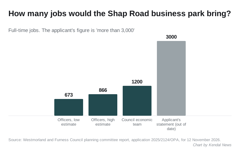
The applicant’s planning statement still quotes more than 3,000 jobs. The officers’ report says that figure is out of date and that the applicant accepts this, because the mix of uses has since changed.
Using national employment density guidance, officers estimate between 673 and 866 full-time jobs, depending on how much of the industrial space is used for heavier industry. The council’s economic development team gave a figure of up to 1,200.
Who objects, and who does not
The council received 25 representations: 23 objections and two letters of support. The supporters say established local firms struggle to find modern industrial space of any size.
Kendal Town Council has recommended refusal four times, most recently on 23 October 2026. Its concerns include:
- traffic, and how the transport figures square with the jobs claimed
- the loss of green fields outside the town’s boundary
- the scheme’s viability
Burneside Parish Council fears more traffic on the road from the A6 through Burneside to the A591, which it says is already used as a “rat run”. It also says the buildings would look large from its parish. Skelsmergh and Scalthwaiterigg Parish Council objects mainly on landscape grounds.
Objectors also raised:
- speeding on this stretch of the A6, with no safe crossing point
- poor bus links and no continuous footpath or cycle path to the site
- the loss of drumlins and the effect on views towards the Lake District
- noise, light pollution and flood risk
The council’s own highways team raised no objection, subject to conditions and a legal agreement. The report says it has not identified any severe impact on the road network.
What officers want in return
The recommendation is approval, subject to a section 106 agreement that would include:
- a bond of up to £200,000 a year for five years to pay for a bus service to the site, if the travel plan fails to cut single-occupancy car journeys by 10%
- a travel plan monitoring fee of £6,600
- a biodiversity net gain monitoring fee of £13,200
Officers accept the scheme would do “moderate” harm to the local landscape, particularly for people driving into Kendal on the A6 and walkers on the two public footpaths that cross the site. They conclude that the economic benefits are not “substantially outweighed” by that harm.
What it means for you
- The decision is on Thursday 12 November. The meeting is in the District Council Chamber at Kendal Town Hall and is open to the public.
- To speak at the meeting, the agenda says you must apply to the committee’s democratic services officer by one minute past midnight, three working days before the meeting. Contact details are on the meeting page.
- Approval would be outline only. The look, layout and access details would need a further application before anything is built.
- If you drive the A6 north of Kendal, the main entrance would be a new junction with a right-turn lane for southbound traffic.
We will report the committee’s decision. Planning applications in the town are on our Kendal planning news page.
Have your say